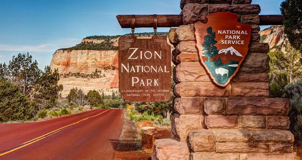
Zion National Park Information Guide

Welcome to the Zion National Park Information Guide.
Here you will find all you need to know about the natural history of the park.
Learn about the geology, trees, mammals, birds, or other plants and wildlife of the area.

-SPONSORED LINKS-
Zion National Park Lodging
Zion National Park Maps
Zion National Park Hotels
Zion National Park Camping
Zion National Park Photos
Zion National Park Tours 
Utah Weather
Banded Lizard - Corel ©

Sponsored National Park Search

Zion National Park Information
Establishment Flora & Fauna Geology History Size & Visitation


Establishment

Zion National park was established in 1909 as Mukuntuweap National Monument. It became Zion National Park in 1919. The name "Zion" meaning "place of refuge," was given to the canyon by Mormon pioneers. Protected within Zion National Park's 229 square miles (593.1 km) is a spectacular cliff-and-canyon landscape and wilderness full of the unexpected including the world's largest arch - Kolob Arch - with a span that measures 310 feet (94.5 m).

The Zion National Monument, in the county of Washington, State of Utah, is declared to be a national park and dedicated as such for the benefit and enjoyment of the people, under the name of the Zion National Park, under which name the aforesaid national park shall be maintained by allotment of funds heretofore or hereafter appropriated for the national monuments, until such time as an independent appropriation is made therefor by Congress.

Consolidation of Zion National Park and Zion National Monument

For the purpose of combining Zion National Park and Zion National Monument, Utah, in a single National park unit, in the interest of efficient administration and to preserve adequately the features thereof, Zion National Park on and after July 11, 1956, shall comprise the present area of the National Park and the present area of the Zion National Monument: Provided, That the enactment of sections 346b to 346d of this title shall not affect adversely any valid rights or privileges heretofore existing within the areas hereby established as the Zion National Park.


Size and Visitation

Zion National Park is 229 square miles / 593.1 km. Elevation's lowest point is 3,700 feet / 1,128 meters, and highest point is 8,726 feet / 2,660 meters.

The majority of park visitors come during Spring and Fall and are lowest in December through March. Visitation in 1920 was 3,692, while visitation in 1996 it was 2.6 million
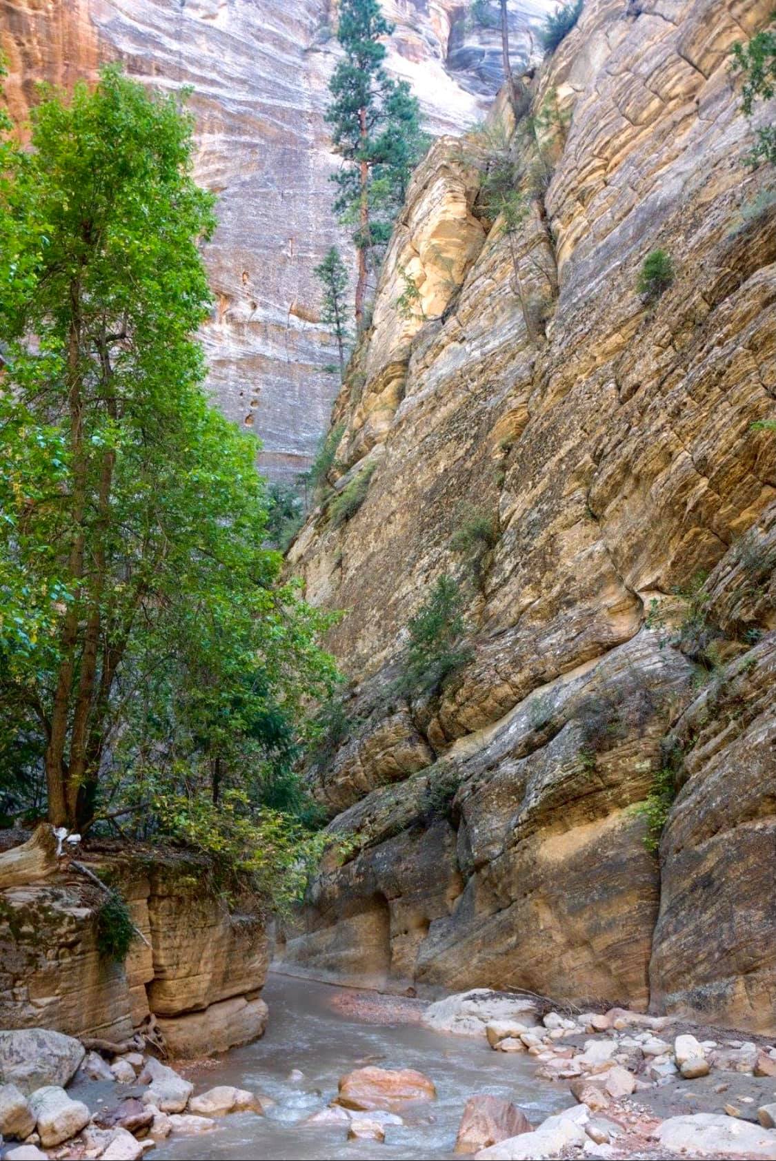
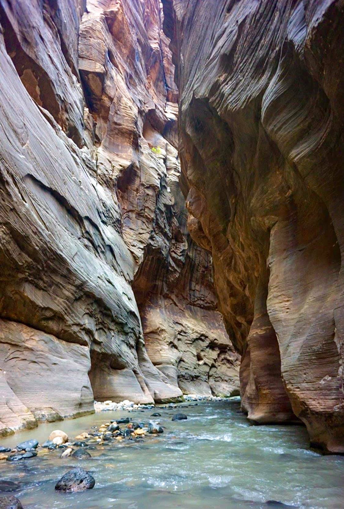


Geology

Zion Canyon reveals many events of middle geologic times. The story of Zion begins where that of Grand Canyon ends and ends where that of Bryce canyon begins. The geologic records of 2 billion years are incorporated in these three park areas, all located within 120 miles of each other.

Zion National Park has witnessed many changes in landscape and climate. At times it was covered by the sea; at other times broad rivers traversed its surface; at still other times it was swept by desert winds. Many of the rocks were laid down by water as gravel, sand, mud, and limy ooze. These were consolidated into conglomerates, sandstones, shales, and limestones by the weight of layers above them and by the lime, silica, and iron that cemented the grains.

Embedded in the rocks are occasional fossil sea shells, fish, trees, snails and bones and tracks of land animals that sought flood in flood plains, in forests and among sand dunes.

Geologist divide sedimentary rocks into formations which differ from each other in such features as mineral content, extent and thickness of individual layers, and kinds of fossils. Each individual formation reveals the geography, climate, fauna and flora of its time.

The formations of Zion were laid down one above the other, in orderly succession. Seven formations are prominently displayed within the park; their edges appear along the canyon walls. The oldest, Moenkopi appears in the lowest park elevations while the youngest, the Carmel, appears at the tops of some of Zion's lofty features. Because the layers dip gently northward, the oldest strata are exposed at the south margin of the park along the Virgin River and the youngest are exposed to the north.

The Moenkopi Formation

Along the Virgin River about 1800 feet of Moenkopi is displayed as a landscape of brightly colored bands. The highway between the towns of Virgin and Rockville, Utah, traverses successively higher beds until the top is reached at the mouth of the Parunweap Canyon. This formation is composed of many thousands of thin layers of sandstone and shale. It also contains beds of limestone and gypsum, deposited in the sea, for the most part, and on coastal plains and along inland streams. The lower third of this formation consists of oil bearing, sandy limestones and shales overlain by several hundred feet of red, brown and pink gypsum bearing sandy shales capped by a few beds of fossiliferous limestone that form a prominent cliff. The upper two thirds consists of strongly colored red sandy shales that include as a middle diversion the remarkable group of gray, white, pink, and soft gypsiferous beds known as the Shnabkaib Shale member.

After Moenkopi sediments had been deposited in the sea and along its borders they were partially removed by erosion, resulting in an uneven surface on which the sands and gravels of the succeeding Shinarump were laid down. The irregular contact between the two formations is apparent between the towns of Rockville and Grafton.

The Chinle Formation

Resting on the Moenkopi is the Shinarump conglomerate, the lower of the Chinle formation. Although less than 100 feet thick, the Shinarump is a prominent cliff maker. It is the caprock of sloping walls at the mouth of the Parunuweap Canyon. It forms the caplike mesas on both sides of the Virgin River at Huber Wash and Coalpits Wash. The Shinarump consists chiefly of white, gray, and brown conglomerate; coarse sandstone; thin, short lenses of fine colored sandy shale; and fossil wood. The dominant pebbles, well rounded, clouded and translucent, are white, yellow, and gray quartz; red, brown, and white quartz rock composed of firmly cemented quartz grains; and blue-gray limestone.

Locally, cavities in the fossil wood contain yellow carnotite or other uranium minerals. The space between pebbles are filled with iron and manganese oxides and copper sulfide. The formation is typically displayed in the cliffs at Rockville.

Petrified wood is contained in the Chinle, along with marvelous assemblages of shales, soft sandstones, weathered volcanic ash, and many kinds of calcareous rocks colored with bands, streaks, and irregular blotches of yellow, lavender, purple, pink, lilac, ash gray and various shades of red, blue and brown. These are the most richly colored beds in Utah.

The Moenave Formation

Above the Chinle, the Moenave formation consists of two divisions, the lower, slope forming unit called the Dinosaur Canyon Sandstone member and an upper, cliff forming unit called the Springdale Sandstone member. The Dinosaur Canyon member ranges from 140 to 375 feet thick and consists of thin, interbedded siltstone, mudstone and fine sandstone beds that maintain a regularity of thickness over quite a distance. This regularity, plus the fish skeletal parts and scales found in them, led geologists to conclude that the beds were deposited in a lake. Some lake waters became shallow and disappeared.

The overlying Springdale Sandstone member forms almost vertical cliffs 75 to 150 feet high. It is a pale reddish brown. The Springdale Sandstone is mostly stream deposits.

The Kayenta Formation

The Kayenta forms a shelving slope worn chiefly on thin, maroon colored sandstone. The sediments that comprise the Kayenta were deposited upon the Moenvae by intermittent streams.

The Navajo Sandstone

Resting upon the Kayenta, the Navajo Sandstone (White Cliffs) is the most visible of Zion's formations. From it the temples and towers, the cliffs and canyon walls have been carved. They make Zion National Park unique. The Navajo is basically a huge mass of remarkably homogeneous, fine grained, friable sandstone, laid down about 170 million years ago. Usually the lower half of the Navajo is light red, and the upper half is light tan. Fully 98 percent of the Navajo consists of rounded grains of translucent quartz, many of them frosted and wind etched. The grains are held together by lime, iron oxides and claylike substance, but the cement is weak and the rock is remarkably porous and friable (crumbly).

The Temple Cap Formation

For a brief period after the Navajo desert sands had been deposited, flood waters carried red muds over the dunes. The climate returned to more desert like conditions. The Temple Cap formation is recorded in a thin layer of clay and slit, the source of the red streaking that stains the upper faces of the Navajo Sandstone that lie directly below, such as the Altar of Sacrifice. It is also apparent in the thick sandstone layer that forms the caprock of West Temple and East Temple.

The Carmel Formation

The thin resistant Carmel is the youngest of the formations that are exposed within the park. Carmel is composed of hard, compact limestone in groups of beds one to four feet thick. Bedding and composition reveal that Carmel originated as silts deposited in a shallow sea, and abundant fossils fix its age at about 145 million years. This widespread formation appears in isolated remnants atop West Temple and East Temple, and extensively upon Horse Pasture Plateau and many mesas on Kolob Terrace.

Improbable as it may seem, the evidence clearly reveals that Zion Canyon is the result chiefly of the work of the Virgin River. The Virgin River's tranquil beauty and life giving waters belie the tremendous power by which it has sliced through ageless rock layers to carve Zion Canyon.


Flora and Fauna

A desert (actually an upper extension of the broad Mojave desert) penetrates much of the lower canyon levels. Yet, amidst this aridity, the moisture provided by streams and springs supports relatively lush communities of plants and a wide diversity of wildlife.

Flora

Zion National Park, with both hanging gardens and dry, sun drenched slopes has the richest diversity of plants in Utah with almost 800 native species. At the right season, small clusters of shooting stars, monkey flowers, larkspurs, miner's lettuce, evening primrose and, surprisingly, an occasional orchard will bloom.

On the dry slopes, where the sun has baked the earth and drawn from the soil and air almost all of the moisture that may have been present, the opposite is true. No moist greenery here, instead there are shrub live oak, low grayish junipers, an occasional pinyon pine, and at ground level, sparse clumps of bunchgrasses and a few scattered low shrubs, globe mallow and squawbush.

The spring cycle begins in March or April with the blooming of sand buttercup, chorispora, and early Indian paintbrush. Early May is the time for the violet, orchid, pentstemon, sego lily and in shady nooks, the columbine and monkey flower. During the excessive heat of the summer, day blooming plants are largely replaced by such night blooming species as evening primrose, four o'clock, spiderwort and the glorious sacred datura, a veritable "moonlight garden".

During the late summer cycle, Zion's roads and trails lead through fields of asters, sunflowers, bee flowers, Wyoming paintbrush and sweet clover. The cool shady nooks are made more brilliant by the present of the cardinal flower.

On the floors of the canyons, groves of box elder, willow, cottonwood and ash grow where water tables lie close to the surface. Above them on the talus slopes and here and there in cracks on towering walls, grow juniper, pinyon pine, live oak and manzanita. On the Kolob Terrace above the canyon walls at the elevation of about 7,000 feet, ponderosa pine, white fir, Douglas fir and quaking aspen are the dominant species. Yuccas grow high on the rim, while damp niches provide suitable locations for ferns and other plants that normally prefer cooler climates.

Fauna

There are more than 285 species of birds recorded in Zion National Park. These birds range from typical desert dwellers such as the greater roadrunner, rock wren, black throated sparrow, and Gambel's quail to birds associated with water habitats such as the great blue heron and American dipper (water ouzel).

Mammal residents present an equally mixed group. The mountain lion's natural shyness and fear of humans make actual sightings an occasion of special note, although backcountry areas such as the Kolob and Parunweap canyons support a number of these cats. Their presence is indicated by signs such as a set of tracks or the remains of an occasional kill. Mule deer on the other hand are commonly seen and are associated with the mountain lion in a prey predator relationship. There is also the presence of the desert cottontail, striped and spotted skunks, mountain vole and water shrew.

A strong nocturnal creature, the ring tailed cat is rarely sighted. The gray fox lives in much the same territory as the ring tailed cat and shares its food habitat. It is rare that two kinds of animals so similar in their habits as these overlap so closely in range. Usually when such overlap occurs, one will force the other out. In this case, when their activities are viewed and a third dimension is considered, it is found that the ringtail, its limbs and toes well adapted for moving both up and down tree trunks, an excellent climber, often forages at a high level. While the gray fox, although able to climb trees, is principally a ground dweller and rarely looks elsewhere for its livelihood.

Banded geckos, tiger salamanders, canyon tree frogs and desert horned lizards are representatives of an abundant population of reptiles and amphibians. The western rattlesnake may make an occasional appearance.

Unique among the park animals and the Zion snails, invertebrates that have become adapted to a moist niche in the desert at Zion, and are only found on wet walls of the sheer cliffs along the Virgin River Narrow.

Commonly seen animals include mule deer, rock squirrels, lizards, and many species of song birds. Rare or endangered species include peregrine falcons, mountain lions and some species, like the Zion snail, found nowhere else on earth.


History

The earliest evidence of human occupation in Zion and the vicinity is that of the Basket Makers Their fragmentary remains in this area have been noted and dated back to at least A.D. 500. The Basket Makers appear to have lived in individual family units and subsisted by hunting small and large game, collecting roots, seeds, nut and berries, and cultivating small plots of corn.

By about A.D. 750 life became more sedentary and the people appear to have depended more heavily on small scale horticulture. When farmland was adequate to support more than one family in one place, the people joined together in larger groups, in the Anasazi tradition. A marginal or fringe settlement of this type was established in Parunuweap Canyon.

The Anasazi people constituted one of the divisions of the Pueblo culture. One of the ethnologic divisions of the Anasazi is the Kayenta, or the Kayenta Virgin. The basic pattern of small, scattered farmsteads persisted until about A.D. 1200 when the Zion area was abandoned, possible because of change in the rainfall pattern, pressure from other peoples, or a combination of factors.

Around the same time the Anasazi peoples were living in the southern part of the park area, the northern portion may have occupied or at least seasonally visited by groups belonging to the Fremont culture. Fremont peoples, who occupied the northern two thirds of Utah, lived in small pit house villages.

After the Anasazi and Fremont peoples left the Zion area, about A.D.1200, the area was apparently not occupied again until the 19th century, although the area may have been visited for several hundred years by small bands of Paiute foragers hunting and collecting wild foods.

The first recorded visit by people of European descent to southwestern Utah was made by members of the Dominguez Escalante expedition. At the time of the American Revolution, these Spanish padres undertook an adventurous journey in an attempt to find a viable overland route from the settlements at Santa Fe, New Mexico to those at Monterey, California. Passing by areas in which the towns of Beaver and Cedar City now lie, he forded the Virgin River near the present town of La Verkin, traverses the Uinkaret, Kanab, and Kaibab plateaus, and crossed the Glen Canyon of the Colorado at the place since known as "Crossing of the Fathers". From the river he followed established trails back to Santa Fe.

Fifty years after Escalante's trip through Utah, the region adjoining the Zion National Park region was explored by a company of about 16 men under the leadership of Jedediah S. Smith, one of the many fur traders whose history make up the history of the West during the first half of the 19th century.

It seems that neither Escalante nor Smith or any other trader of his time actually saw Zion Canyon. These early travelers diverged little from the most expedient and feasible routes.

Soon after the founding of Salt Lake, in 1847, scouts were sent forward across the High Plateau and among the "southern mountains" to select sites where water and arable lands were available. Favorable reports from small settlements founded at Toquerville and Virgin City (1885) led to systematic colonization, beginning in 1861, when "several hundred" families moved from northern Utah to lands along the Virgin River.

Guided by friendly Indians to the mouth of this canyon (Zion Canyon), Nephi Johnson penetrated it in November 1858 as far as the Great White Throne and perhaps to the Narrows. The land was thoroughly examined in 1861 by Joseph Black who found suitable farm sites on the flat lands downstream from, and in front of the site of Zion Lodge, and upstream near the Grotto. On these lands a few settlers cultivated corn, tobacco, garden vegetables and fruit trees. On the canyon floor and the plateau above they grazed cattle and sheep until 1909, when the area was withdrawn as a national monument.

Due to its inaccessibility, the public knew little of the Zion region until the summer of 1908 when Leo A. Snow, a United States Deputy Surveyor from St. George, Utah, did a general land survey of the area and presented his report to the Department of the Interior. His findings were so impressive that they were brought to the attention of President Taft with the suggestion that the area should be set aside and preserved. In 1909, the area was established, by presidential proclamation, to be the Mukuntuweap National Monument.

In 1918, the locally unpopular name "Mukuntuweap" was changed to "Zion" and in 1919, the area was made a national park thus opening the way to make the region accessible and for providing accommodations for visitors.


Zion National Park Travel Packets

Zion National Park Links
Bullet Accessibility
Bullet Activity & Calendar Page
Bullet Address, Email & Phone Guide
Bullet Backcountry Camping
Bullet Biking
Bullet Brochures, Maps, Written Info
Bullet Camping Guide
Bullet Climbing
Bullet Establishment
Bullet Fees
Bullet Fishing
Bullet Flora & Fauna
Bullet Geology
Bullet Grand Circle
Bullet Hiking Guide
Bullet History
Bullet Horseback Rides
Bullet Jobs, SCA, Volunteer Positions
Bullet Junior Ranger Programs
Bullet Large Vehicle Restrictions
Bullet Location
Bullet Lodging Guide
Bullet Map Guide
Bullet Other Utah Sites
Bullet Park Information
Bullet Pet Information
Bullet Picnic Areas
Bullet Roads
Bullet Search
Bullet Sights Guide
Bullet Size & Visitation Info
Bullet The Narrows
Bullet Travel Packets
Bullet Travel Guide
Bullet Visitors Guide
Bullet Weather
Bullet Winter
Bullet Winter Hiking

Zion National Park
Utah National Parks Page
Back to National Parks
Equip yourself for your next National Park adventure by visiting our Outdoor Gear and Equipment Store


by John William Uhler

Copyright © 1995 - 2007 Hillclimb Media

For information about Advertising on this Page - Click here

This site is in no way associated with the United States Government, the Department of the Interior or the National Park Service

Demand Media Network

Privacy Policy